Charles and the November rain: from Portugal to Croatia
Selected gauges across six countries show how unevenly the November rain was distributed. Lisboa/Relogio reported 104.0 mm over 11 November UTC, Cannes 140.7 mm over 12 November UTC, and two western Slovenian sites more than 100 mm in the 24 hours ending on the morning of 13 November. These are local measurements over different reporting windows, rather than country averages.
The comparison covers eight stations in Portugal, Spain, France, Italy, Slovenia and Croatia. Portugal’s main encounter with Charles was on 11 November, according to IPMA. The later observations extend the account of the wet-weather sequence without assuming that every downpour belonged to that one named storm.
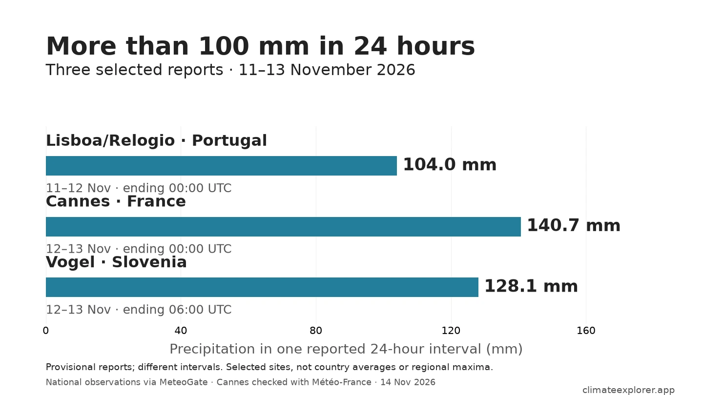
Source: National observations via MeteoGate; Cannes also reproduced from original Météo-France hourly data. Snapshot 14 November 2026.
Lisbon’s 104 mm belongs to the rain on 11 November
At Lisboa/Relogio, the selected 104.0 mm report covers 00:00 UTC on 11 November to 00:00 UTC on 12 November. It is dated 12 November because the timestamp marks the end of the measurement. Adding the 24 hourly reports over the same interval independently reproduces the total.
A millimetre of rain corresponds to one litre of water over a square metre. The Lisbon report therefore represents 104 litres over each square metre at the gauge, rather than a uniform amount across the city.
On Spain’s northern coast, Castro Urdiales EDAR reported 53.6 mm over 12 November 06:00–13 November 06:00 UTC. Within that day, 22.0 mm fell in one reported hour, from 12:00 to 13:00 UTC on 12 November. The daily total describes the overall amount; the hourly report shows one concentrated burst.
Cannes adds a very wet day on the French coast
At Cannes, 140.7 mm was reported for 12 November 00:00–13 November 00:00 UTC. The original Météo-France hourly archive independently reproduces this amount, with all 24 hourly values present. Its latest hours still have provisional quality status, so the amount is retained as provisional here.
The French result adds a separate coastal observation between the Iberian and northern-Adriatic sites. It is a station total, not the amount everywhere in Cannes or across the Côte d’Azur. All intervals in this comparison use UTC, the common time reference; the French window runs from 01:00 to 01:00 in local November time.
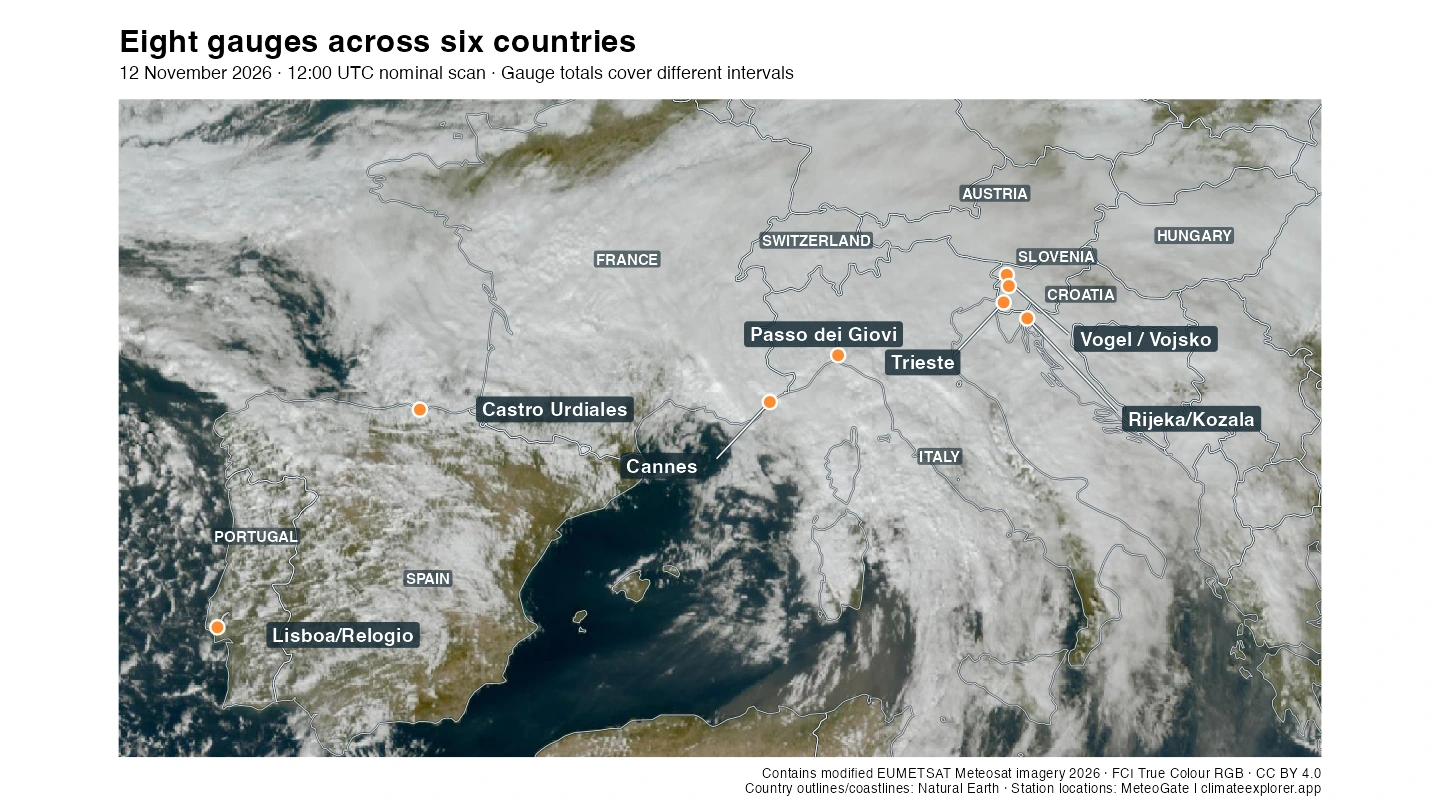
Source: Contains modified EUMETSAT Meteosat imagery 2026, CC BY 4.0. Boundaries and coastlines: Natural Earth; stations: MeteoGate. Geographic outlines, labels and markers added by Climate Explorer.
Northern Italy and the Adriatic show different local amounts
The two Italian sites cover the same 12 November 00:00–13 November 00:00 UTC interval as Cannes: 75.9 mm at Passo dei Giovi, in northwestern Italy, and 38.0 mm at Trieste, on the northeastern coast. These are different observing sites, not an average for northern Italy or a measurement of an entire warning area.
Across the northern Adriatic, Rijeka/Kozala in Croatia reported 73.1 mm over 12 November 06:00–13 November 06:00 UTC. The same start and end times apply to Vogel’s 128.1 mm and Vojsko’s 113.2 mm in western Slovenia. This matched clock helps compare the reports, while the different locations and observing conditions remain important.
The Slovenian timing is consistent with the civil-protection bulletin quoting ARSO: widespread heavy rain was forecast from the afternoon of 12 November into the middle of 13 November, initially strongest in the southwest. The warning describes what was expected; the gauges supply the reported amounts.
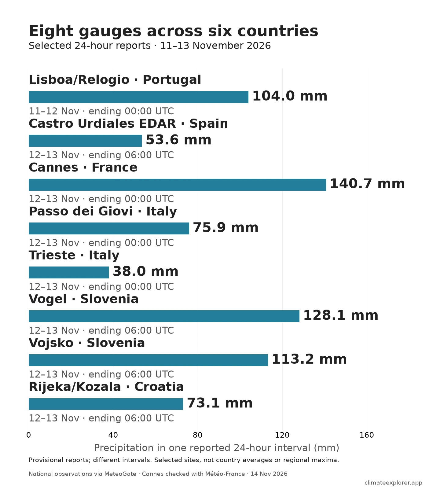
Source: National observations via MeteoGate; the Cannes daily report also matches the original Météo-France hourly sum. Provisional data, 14 November 2026.
The broader selection puts measurements from six countries on the page, but it is still a small geographic sample. Its bars are neither national maxima nor country-wide rainfall estimates. The Lisbon interval also precedes the other selected intervals, so this is not a simultaneous map of one day’s rain across Europe.
Charles is part of a wider weather sequence
IPMA named Charles on 9 November and identifies its passage across mainland Portugal on 11 November. AEMET’s special bulletin for Spain described both the effects of Bruna and the subsequent arrival of Charles: the Iberian episode already involved more than one named system.
Farther east, Italy’s Civil Protection issued a red alert for northwestern Tuscany for 12 November. Its dated bulletin assigned orange to sectors of Liguria, Emilia-Romagna and Tuscany, and yellow to parts of Friuli–Venezia Giulia. Warning colours describe anticipated hazards in defined areas and periods; they do not establish the rainfall measured at the selected gauges.
Météo-France’s update on 13 November described renewed rain crossing southern France on 14 November after an improvement on Friday. These official accounts support a sequence of wet weather across Europe, but do not establish that every later downpour belonged to Charles.
How to read and verify the reports
The selected amounts come from national observations distributed through MeteoGate, preserved in the public archive used by EuroMeteo Explorer. Each daily figure covers an explicitly defined 24-hour interval. French provider records use a different method label from the other selected reports; their explicit interval is checked against the original Météo-France hourly data. Instantaneous counters and overlapping daily sums are not used to build totals.
These are provisional reports. MeteoGate’s archive supplies no provider quality-control flags. Additional checks reproduce Lisbon’s amount from its hourly series, Cannes from the national hourly archive, and the Slovenian amounts to the nearest whole millimetre in ARSO’s own reports. Separate national amount confirmation is not claimed for the selected Italian or Croatian reports.
Explore the observations: Open EuroMeteo Explorer, select the station names in the annex and precipitation over 11–13 November 2026. Choose the 24-hour duration for the daily comparison; keep Castro’s one-hour burst separate. The annex retains the exact endpoints and identifiers if the interactive display’s available period has moved on.
For a spatial view, open OPERA Radar Explorer and select historical 1-Hour Rainfall Accumulation (ACRR) maps for 12–13 November 2026. Each map estimates precipitation over the preceding hour. Use it to explore where rain was detected; local amounts in this article come from the gauges.
Conclusion
The eight stations broaden the picture from Portugal and Spain through the French coast and northern Italy to Slovenia and Croatia. Selected gauges in Portugal, France and Slovenia exceeded 100 mm in their respective 24-hour reports, while the other sites show different local amounts. The reporting windows establish the chronology; they do not turn sparse measurements into a continuous storm track or a regional rainfall field.
Editor’s note: Data current as of 14 November 2026. Selected gauge observations end at 06:00 UTC on 13 November. All amounts remain provisional; these selected reporting windows are not a final event total.
Data Annex
The table retains each station’s identifier in the MeteoGate observation archive. WIGOS is the globally unique station identifier system; OSCAR confirms the listed identities and elevations except where noted. Cannes also has native Météo-France identifier 06029001: its source name and coordinates match the MeteoGate entry, but no canonical OSCAR alias is inferred. The coordinates shown are those supplied with the observations.
| Station | Country | Archive identifier | Latitude | Longitude | Elevation | Classification |
|---|---|---|---|---|---|---|
| Lisboa/Relogio | Portugal | 0-620-2101-08580 | 38.76179 | −9.12540 | 114.1 m | Land, fixed |
| Castro Urdiales EDAR | Spain | 0-20000-0-08020 | 43.39473 | −3.23388 | Not established | Not independently verified |
| Cannes | France | 0-250-0-07684 | 43.55650 | 6.95050 | 2 m | Type not specified in source used |
| Passo dei Giovi | Italy | 0-20000-0-16119 | 44.55222 | 8.93750 | 487 m | Land, fixed |
| Trieste | Italy | 0-20000-0-16110 | 45.67694 | 13.75472 | 3 m | Land, fixed |
| Vogel | Slovenia | 0-20000-0-14006 | 46.26389 | 13.84556 | 1535 m | Land, fixed |
| Vojsko | Slovenia | 0-20000-0-14009 | 46.02528 | 13.90778 | 1067 m | Land, fixed |
| Rijeka/Kozala | Croatia | 0-20000-0-14216 | 45.33700 | 14.44300 | 120 m | Land, fixed |
| Station | Start UTC (2026) | End UTC (2026) | Duration | Reported precipitation |
|---|---|---|---|---|
| Lisboa/Relogio | 11 Nov 00:00 | 12 Nov 00:00 | 24 h | 104.0 mm |
| Castro Urdiales EDAR | 12 Nov 06:00 | 13 Nov 06:00 | 24 h | 53.6 mm |
| Cannes | 12 Nov 00:00 | 13 Nov 00:00 | 24 h | 140.7 mm |
| Passo dei Giovi | 12 Nov 00:00 | 13 Nov 00:00 | 24 h | 75.9 mm |
| Trieste | 12 Nov 00:00 | 13 Nov 00:00 | 24 h | 38.0 mm |
| Vogel | 12 Nov 06:00 | 13 Nov 06:00 | 24 h | 128.1 mm |
| Vojsko | 12 Nov 06:00 | 13 Nov 06:00 | 24 h | 113.2 mm |
| Rijeka/Kozala | 12 Nov 06:00 | 13 Nov 06:00 | 24 h | 73.1 mm |
| Castro Urdiales EDAR | 12 Nov 12:00 | 12 Nov 13:00 | 1 h | 22.0 mm |
Cannes’s national hourly reconstruction contains 24 records: 19 with quality code 1 and five with first-level quality code 9. All five code-9 hours are dry; the full interval remains provisional. At Passo dei Giovi, identical reports at two measurement levels are counted once. The MeteoGate archive’s negative values and instantaneous counters are excluded. These checks are distinct from final provider validation.
The eight selected daily reports, station metadata and Cannes hourly source records are available as CSV files. This comparison describes event amounts; no departure from a climatic normal is calculated.
Data Sources
- IPMA: evolution of depression Charles, published 12 November 2026; Portuguese naming and passage dates.
- AEMET: special bulletin 39/2026, issued 10 November; Bruna/Charles forecast context.
- Italy Civil Protection: red alert in Tuscany, issued 11 November for 12 November.
- ARSO Vogel station reports and ARSO Vojsko station reports, 24-hour precipitation ending 13 November at 07:00 CET; rolling pages consulted 14 November.
- Slovenian Civil Protection: 11 November bulletin, quoting ARSO’s heavy-rain forecast.
- Météo-France: unsettled and rainy weather this week, update consulted from 13 November; page may subsequently change.
- Météo-France hourly observations, including the Alpes-Maritimes source file and field/quality definitions, for the Cannes hourly reconstruction and metadata.
- Public MeteoGate observation archive, daily files for 11–14 November; WMO OSCAR for station identity and elevation.
- EUMETNET OPERA NIMBUS product specification, defining the one-hour accumulation available through OPERA Explorer.
- EUMETSAT EUMETView, MTG-I FCI True Colour RGB, 12 November 2026 at 12:00 UTC nominal scan; EUMETSAT Data Policy, CC BY 4.0. Satellite imagery is cropped, resized and overlaid with geographic outlines, labels and station markers by Climate Explorer.
- Natural Earth for map boundaries and coastlines.