Agneta and the heavy rain in southern Romania
After a day that brought 77.8 mm at Constanța, the latest completed reporting day was much less wet at that station: 7.3 mm by 06:00 UTC on 4 November. Rain continued inland, with 23.9 mm at Giurgiu and 23.1 mm at Craiova over the same 24 hours. ANM’s daily map and the national reports delivered through MeteoGate show the same amounts.
These changing local amounts sit within the wider Mediterranean weather sequence around Agneta. Dated official bulletins described the low first over southern Italy and later over Greece, moving east. Satellite imagery gives a view of the cloud system; station observations show where and when precipitation was measured.
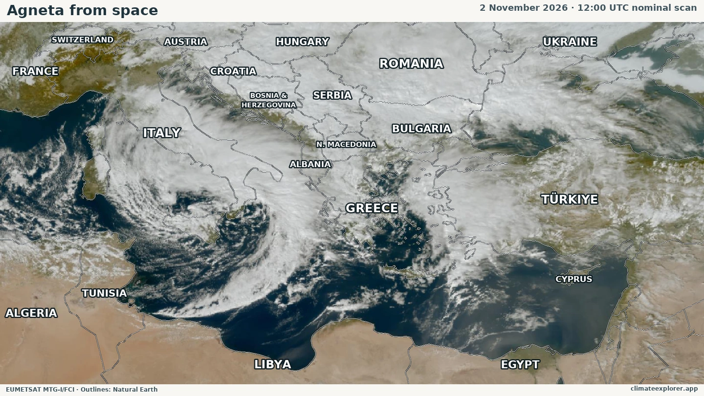
Image source: EUMETSAT EUMETView · CC BY 4.0 · Geographic outlines: Natural Earth.
From southern Italy towards Greece
Italy’s meteorological service lists Agneta with an Italian impact date of 2 November. Greek Civil Protection’s bulletin that day described a low over southern Italy moving east and forecast severe weather affecting parts of Greece through 3 November.
The satellite image above comes from 2 November at 12:00 UTC nominal scan time, during that central Mediterranean phase. It shows a curved cloud system around southern Italy and Sicily, with broader cloud bands extending across the region. It is a processed true-colour view of measured satellite channels, rather than a map of rainfall amounts.
A later AEMET Mediterranean marine bulletin, valid from 20:00 UTC on 3 November to 20:00 UTC on 4 November, described Agneta over Greece, moving east. Together, these dated descriptions provide a broad progression across the Mediterranean. They do not locate its centre precisely at every intervening hour.
A cyclone is a low-pressure weather system, with anticlockwise circulation in the Northern Hemisphere. Rising moist air can cool and condense into cloud and precipitation, while associated fronts spread the weather beyond the centre. That is why the cloud system, the low’s position and a station’s accumulated rain answer different parts of the story.
The latest rain was lighter at the coast, but continued inland
The latest daily observations cover 06:00 UTC on 3 November to 06:00 UTC on 4 November. Constanța’s 7.3 mm followed 77.8 mm during the preceding reporting day. Drobeta-Turnu Severin recorded 7.6 mm in the latest day, while Bucharest-Filaret recorded 14.6 mm.
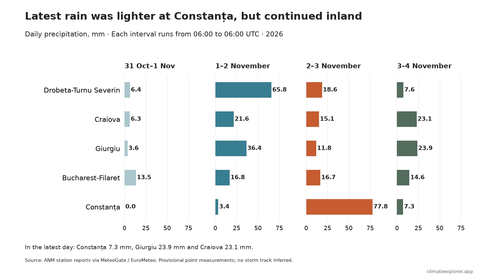
The largest of the four selected daily reports came at different times. Drobeta’s 65.8 mm fell in the interval ending on the morning of 2 November; Constanța’s 77.8 mm came in the following reporting day. At Craiova, the latest 23.1 mm was its largest of these four daily amounts. These are differences between selected stations, rather than an observed track of the cyclone.
Four days of precipitation across the region
Over the common 31 October 06:00–4 November 06:00 UTC window, the selected southern Romanian totals were 98.4 mm at Drobeta, 88.5 mm at Constanța, 75.7 mm at Giurgiu, 66.1 mm at Craiova and 61.6 mm at Bucharest-Filaret. These inland, coastal and urban sites give geographic contrasts without claiming a regional maximum.
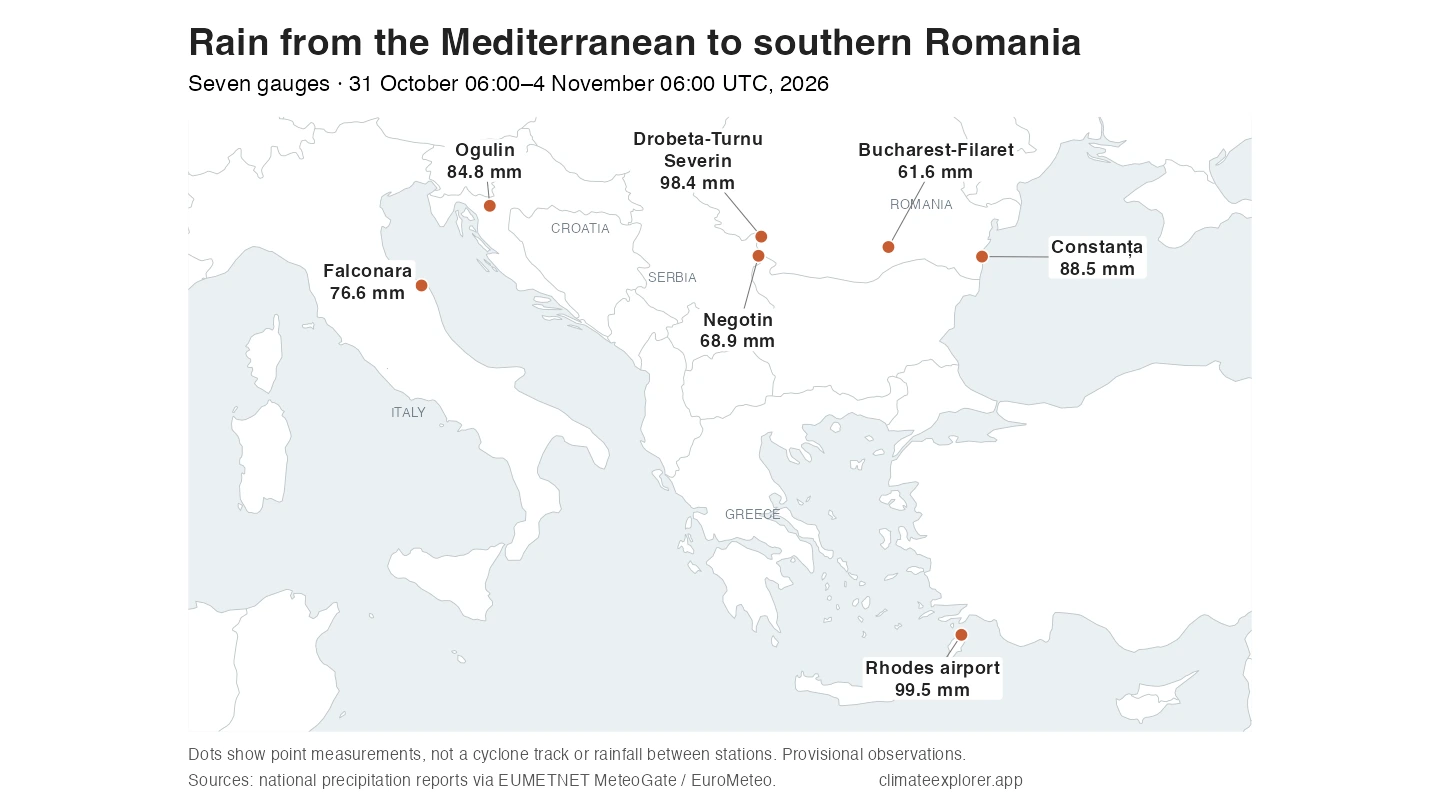
The same four-day comparison gives 99.5 mm at Rhodes airport in Greece, 84.8 mm at Ogulin in Croatia, 76.6 mm at Falconara in Italy and 68.9 mm at Negotin in Serbia. Each value describes a station, not a whole country or the rainfall between the points.
The comparison includes rain before Agneta’s forecast approach to Romania. Contemporary Romanian reporting distinguished the preceding cyclonic weather from the approaching main system. The daily detail therefore matters: the entire four-day accumulation cannot be assigned to Agneta from the totals alone.
How the observations were compared
The article uses national station reports through EUMETNET MeteoGate and the EuroMeteo archive, supplemented by the latest primary reports. At eight sites, four consecutive daily reports cover the 96 hours; Falconara uses eight consecutive 12-hour reports. The calculation adds non-overlapping intervals without filling gaps. Amounts are millimetres of water-equivalent precipitation and remain provisional.
Explore the observations: the EuroMeteo Explorer and EuroMeteo guide provide the reader-facing route into the dataset. The annex lists the WIGOS identifiers—the unique station codes—and exact periods used here. The earlier reports are preserved in the archive after they leave the primary service’s shorter recent window.
Conclusion
The Mediterranean cyclone’s dated evolution provides the weather context, while the updated observations show how the rain varied locally. Constanța’s latest daily amount was lower than the preceding day’s downpour, yet rain continued at the selected inland sites. The four-day totals show the accumulation; the daily reports keep earlier and more recent phases visible.
Editor’s note: Observations are current as of 4 November 2026 at 06:00 UTC (08:00 in Romania), the latest common completed daily interval for these stations. The satellite image is from 2 November at 12:00 UTC nominal scan time. These are provisional observations within a wider weather episode, not final totals attributed wholly to Agneta.
Data Annex
All four-day totals cover 31 October 2026 06:00 UTC–4 November 2026 06:00 UTC. Daily amounts use consecutive 06:00–06:00 UTC reporting periods.
| Station | Country | WIGOS identifier | Latitude | Longitude |
|---|---|---|---|---|
| Falconara | Italy | 0-20000-0-16191 | 43.61667 | 13.36028 |
| Rhodes airport | Greece | 0-20000-0-16749 | 36.40000 | 28.08333 |
| Ogulin | Croatia | 0-20000-0-14328 | 45.26300 | 15.22200 |
| Negotin | Serbia | 0-20000-0-13295 | 44.23000 | 22.55000 |
| Drobeta-Turnu Severin | Romania | 0-20000-0-15410 | 44.62639 | 22.62583 |
| Craiova | Romania | 0-20000-0-15450 | 44.31003 | 23.86695 |
| Giurgiu | Romania | 0-20000-0-15491 | 43.87500 | 25.93250 |
| Bucharest-Filaret | Romania | 0-20000-0-15422 | 44.41195 | 26.09361 |
| Constanța | Romania | 0-20000-0-15480 | 44.21389 | 28.64556 |
| Station | Four-day total (mm) | Latest 24 hours (mm) |
|---|---|---|
| Falconara | 76.6 | 0.0 |
| Rhodes airport | 99.5 | 0.3 |
| Ogulin | 84.8 | 11.6 |
| Negotin | 68.9 | 11.2 |
| Drobeta-Turnu Severin | 98.4 | 7.6 |
| Craiova | 66.1 | 23.1 |
| Giurgiu | 75.7 | 23.9 |
| Bucharest-Filaret | 61.6 | 14.6 |
| Constanța | 88.5 | 7.3 |
| Station | 31 Oct–1 Nov | 1–2 November | 2–3 November | 3–4 November |
|---|---|---|---|---|
| Drobeta-Turnu Severin | 6.4 | 65.8 | 18.6 | 7.6 |
| Craiova | 6.3 | 21.6 | 15.1 | 23.1 |
| Giurgiu | 3.6 | 36.4 | 11.8 | 23.9 |
| Bucharest-Filaret | 13.5 | 16.8 | 16.7 | 14.6 |
| Constanța | 0.0 | 3.4 | 77.8 | 7.3 |
Data Sources
- EUMETSAT EUMETView, EUMETSAT Data Policy and CC BY 4.0: dated MTG-I FCI True Colour RGB imagery. Contains modified EUMETSAT Meteosat imagery 2026; cropped and resized by Climate Explorer.
- ANM daily precipitation map: latest Romanian daily observations, ending 4 November at 06:00 UTC.
- Italy’s official storm-naming table, Greek Civil Protection’s 2 November bulletin and AEMET Mediterranean marine bulletins: named-storm identity and dated broad weather descriptions.
- ProTV’s 2 November evening Agneta report: contemporary Romanian reporting distinguishing preceding weather from the approaching main system.
- EUMETNET MeteoGate observations and the EuroMeteo archive: station metadata, durations and precipitation reports.
- Met Office explanation of high and low pressure: general circulation and rainfall mechanism.
