EuroMeteo: Real-Time European Weather Data Explained
The Problem MeteoGate Was Built to Solve
For decades, accessing weather observations across European borders meant navigating a patchwork of national portals, file servers, proprietary formats, and registration walls. A researcher studying a storm crossing from France into Germany had to consult two entirely separate data systems, often with different variable names, time zones, and download procedures.
This fragmentation was not a failure of any single meteorological service. It was a structural consequence of how weather observation networks evolved: country by country, institution by institution, each building infrastructure that served domestic needs first. Cross-border data exchange existed through the WMO’s Global Telecommunication System (GTS), a circuit-switched network designed in the 1960s, but the GTS was built for communication between weather services, not for open public access.
MeteoGate is the European answer to this problem. Developed by EUMETNET — a collaborative network of 33 National Meteorological and Hydrological Services — MeteoGate creates a federated data infrastructure where real-time observations from stations across the continent are discoverable, comparable, and accessible through a single set of modern web standards.
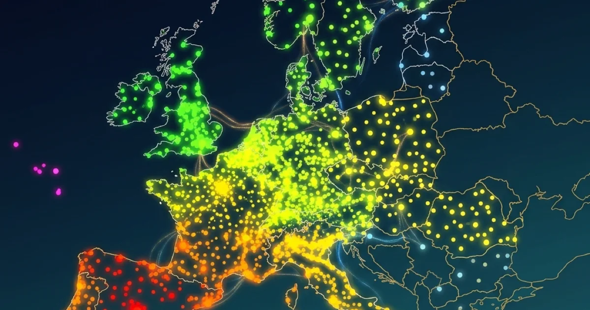
The EuroMeteo Explorer in Climate Explorer is built directly on this MeteoGate feed, giving you a live, interactive view of the data as it flows from national networks.
From GTS to WIS 2.0: Why the Architecture Changed
Understanding why MeteoGate matters requires a brief look at what it replaces.
The Old System: GTS
The Global Telecommunication System was established by the WMO in 1967 to ensure that weather data reached forecast centers worldwide. It worked — remarkably well, for its era — through a hierarchical relay of dedicated circuits and message switches. National centers sent observations to regional hubs, which forwarded them to world centers.
But the GTS was designed for point-to-point delivery between institutions, not for the kind of open, API-driven data access that modern users expect. It carried data in specialized formats (like BUFR and GRIB) optimized for operational forecasting, not for the CSV-and-JSON workflows that researchers, developers, and civic projects rely on today. And critically, the GTS had no mechanism for public discovery or self-service access. You could not simply query it from a browser.
The New Framework: WIS 2.0
The WMO Information System 2.0 (WIS 2.0), declared operational in January 2025, is the GTS’s replacement. It moves weather data exchange from closed circuits to the open internet, using:
- Publish-subscribe messaging (via the WIS 2.0 Global Broker) instead of point-to-point relay. When a station reports a new observation, a notification is published and any subscribed system can retrieve the data.
- Standardized APIs (including OGC API — EDR and OGC API — Features) that allow programmatic, self-service access over HTTP.
- A Global Discovery Catalogue that makes datasets searchable through metadata, so users can find what data exists before requesting it.
WIS 2.0 does not centralize the data. Each national service continues to own, host, and manage its observations. The new system simply standardizes how that data is announced, discovered, and retrieved.
MeteoGate is EUMETNET’s implementation of WIS 2.0 for Europe. It is the platform that connects the 33 member services to the new framework and exposes their data through the shared infrastructure.
E-SOH: The Observation Layer That Powers EuroMeteo
Within MeteoGate, the specific dataset that feeds the EuroMeteo Explorer is called E-SOH — the European Surface Observations HVD (High-Value Dataset).
E-SOH exists because of a specific piece of EU legislation. The EU High-Value Datasets Implementing Regulation (2023/138) requires that certain public datasets — including meteorological observations — be published free of charge, in machine-readable formats, through APIs. The publication deadline was 9 June 2024.
E-SOH is the technical answer to that legal requirement for surface weather observations. It standardizes how land-based station measurements are formatted, described, and delivered across European borders. The key characteristics of E-SOH are:
- Standardized variable names using CF (Climate and Forecast) conventions — so
air_temperaturemeans the same thing whether the data comes from a station in Norway, Spain, or Romania. - Unified temporal alignment — observations are timestamped in UTC, removing the confusion of mixed local time zones.
- Machine-readable delivery — data is served through OGC-compliant APIs, not locked in PDFs, proprietary portals, or national-format text files.
What this means in practice is that a single API call can return temperature, precipitation, wind, and pressure readings from thousands of stations across the continent, all in the same format and coordinate reference system.
What Makes Cross-Border Data Different from National Archives
It is tempting to think of MeteoGate as simply “more data.” But the value of cross-border observations is qualitatively different from what any single national archive provides. The distinction matters for several reasons.
Weather Systems Do Not Respect Borders
A North Atlantic depression tracking from Ireland to Scandinavia passes through the observation networks of at least four or five countries. A Mediterranean cyclone forming near the Balearic Islands may bring heavy rain to southern France, northern Italy, and the Adriatic coast within 24 hours. Alpine foehn winds are felt in Switzerland, Austria, and southern Germany simultaneously.
Analyzing these events with national data alone means stitching together separate downloads with different time stamps, units, and station identifiers. With E-SOH data through the EuroMeteo Explorer, the entire continental picture is visible in a single view — the same variable, the same time step, the same format.
Density Patterns Differ from Country to Country
Not every European country operates the same density of weather stations. Some networks are extremely dense (Germany’s DWD operates over 400 climate stations; France’s Météo-France maintains a similarly large network), while others are sparser. E-SOH makes these density differences visible at a glance. Rather than assuming uniform coverage, a user can immediately see where observation gaps exist and assess whether a region of interest has sufficient station support.
Comparison Without Conversion
One of the most frustrating aspects of multi-national weather analysis is format conversion. A German DWD observation may report wind speed in meters per second, while a legacy format from another service might use knots or kilometers per hour. E-SOH resolves this by enforcing CF-standard variable names and SI-compatible units at the API level. When you compare temperature between Oslo and Lisbon in the EuroMeteo Explorer, the values are directly comparable without any manual unit conversion.
The RODEO and FEMDI Projects: How It Got Built
MeteoGate did not appear overnight. Two key projects created the technical foundation.
RODEO (2023–2025)
The RODEO project (Provision of Open Access to Public Meteorological Data) was a joint effort involving EUMETNET, ECMWF, and 11 national meteorological services, led by the Finnish Meteorological Institute. Running from January 2023 through December 2025, RODEO designed and prototyped the APIs, data catalogues, and shared components that MeteoGate now uses in production.
RODEO’s practical output included the E-SOH observation service, API specifications for radar and climate data, and the initial MeteoGate Data Explorer — the web interface through which the federated catalogue is browsed. The EU Open Data Directive article on this site provides additional background on the legislative framework that motivated this work.
FEMDI (Ongoing)
FEMDI (Federated European Meteo-hydrological Data Infrastructure) is the broader EUMETNET programme under which MeteoGate operates. While RODEO handled the initial build, FEMDI provides the ongoing operational framework — governance, infrastructure funding, service-level agreements, and the roadmap for extending MeteoGate to additional dataset categories (such as climate projections and hydrological data).
Practical Applications of Real-Time Cross-Border Data
Who benefits from pan-European real-time observations? The use cases extend well beyond academic meteorology.
Emergency Management
When a heatwave spreads across southern Europe, emergency coordinators need to know not just where temperatures are dangerous today, but where the heat is heading tomorrow. Cross-border observation feeds allow civil protection agencies to monitor advancing extreme conditions without waiting for bilateral data exchange between services.
Transport and Logistics
Europe’s road, rail, and aviation networks cross dozens of borders daily. A logistics operator managing truck routes from Rotterdam to Milan needs current wind, precipitation, and visibility data along the entire corridor. The same is true for flight dispatchers evaluating en-route conditions across multiple national airspaces.
Energy Grid Management
Europe’s interconnected electricity grid depends on weather-sensitive generation (wind and solar) and weather-sensitive demand (heating and cooling). Grid operators balancing imports and exports across borders need a continental view of current weather conditions — not just forecasts, but ground-truth observations that validate or challenge forecast models in near real-time.
Model Verification
Numerical weather prediction (NWP) models are only as good as their verification data. Running a forecast for central Europe and then comparing the output against observations from a single country gives an incomplete picture. E-SOH observations provide the continental-scale ground truth needed for systematic forecast verification across the model domain.
How EuroMeteo Fits into Climate Explorer
Within Climate Explorer, the EuroMeteo Explorer occupies a specific niche: it is the real-time, cross-border tool in a platform otherwise focused on historical national archives.
If you need the long climate record for a single German station, the DWD Explorer provides daily observations back to the 19th century. If you want multi-century monthly trends, GHCNm offers homogenized data for thousands of global stations. If you need a regional deep dive into French stations with 6-minute resolution, the Météo-France Explorer is purpose-built for that.
EuroMeteo fills the gap that none of those tools can: what is happening right now, across the continent, in a single consistent view. Its strength is breadth and immediacy, not historical depth. Climate Explorer has been archiving the MeteoGate E-SOH feed since 5 March 2026, so the available record grows forward from that date.
For step-by-step instructions on using the explorer interface, see the EuroMeteo User Guide.
Current Limitations and What to Expect
MeteoGate and E-SOH represent a major advance in European data infrastructure, but they are not yet a finished product. Several real-world limitations are worth noting:
- Coverage is expanding, not complete. Not all 33 EUMETNET member services are contributing all station types to E-SOH yet. Some countries report only from synoptic stations, while others include their full climatological and automatic networks. Coverage will continue growing as more services connect.
- Latency varies by country. Some national services push observations within minutes of measurement; others operate on longer reporting cycles. This means that the “most recent hour” on the map may be genuinely current for one country and slightly delayed for another.
- Historical depth is limited. E-SOH is designed for operational, near real-time access. It does not replace the deep historical archives maintained by services like DWD, IMGW, or JMA. Climate Explorer began archiving the E-SOH feed on 5 March 2026, so observations prior to that date are not available in the EuroMeteo Explorer.
- Parameter availability is not uniform. Some stations report a full suite of variables (temperature, precipitation, wind, pressure, humidity, radiation); others report only a subset. This reflects the physical instrumentation at each site, not a data-sharing limitation.
Despite these caveats, MeteoGate already provides the most comprehensive open, real-time view of European surface weather available anywhere. As FEMDI matures and more services onboard additional station types, the coverage and completeness will continue to improve.
Frequently Asked Questions (FAQ)
What is MeteoGate?
MeteoGate is a federated data infrastructure developed by EUMETNET that enables 33 European National Meteorological Services to share observations, forecasts, and climate data through modern web standards. It implements the WMO’s WIS 2.0 framework for the European region.
What does E-SOH stand for?
E-SOH stands for European Surface Observations HVD (High-Value Dataset). It is the specific MeteoGate service that provides standardized, real-time access to land-based weather station observations across Europe, including temperature, precipitation, wind, and pressure.
How is MeteoGate different from checking individual national weather services?
MeteoGate aggregates data from 33 national services into a single, standardized feed. Instead of visiting separate portals with different formats, registration requirements, and variable names, you get all observations through one consistent API using CF-standard variable names and UTC timestamps.
Does EuroMeteo replace the national explorers in Climate Explorer?
No. EuroMeteo is designed for real-time, cross-border monitoring. The national explorers (DWD, Météo-France, IMGW, JMA) provide much deeper historical archives, often spanning decades or centuries, with higher temporal resolution and additional parameters not available through E-SOH.
What replaced the Global Telecommunication System (GTS)?
The WMO Information System 2.0 (WIS 2.0), declared operational in January 2025, is gradually replacing the GTS. WIS 2.0 moves weather data exchange from closed circuits to the open internet, using publish-subscribe messaging, standardized APIs, and a global discovery catalogue.
Data Sources
- EUMETNET MeteoGate / E-SOH: Real-time European meteorological observations.