Midwest Heatwave 2026: When the Night Stayed Hot
At Dubuque, the lowest temperature was only part of the late-June heat story. Hourly observations show how slowly the first evening cooled and how long warm conditions continued.
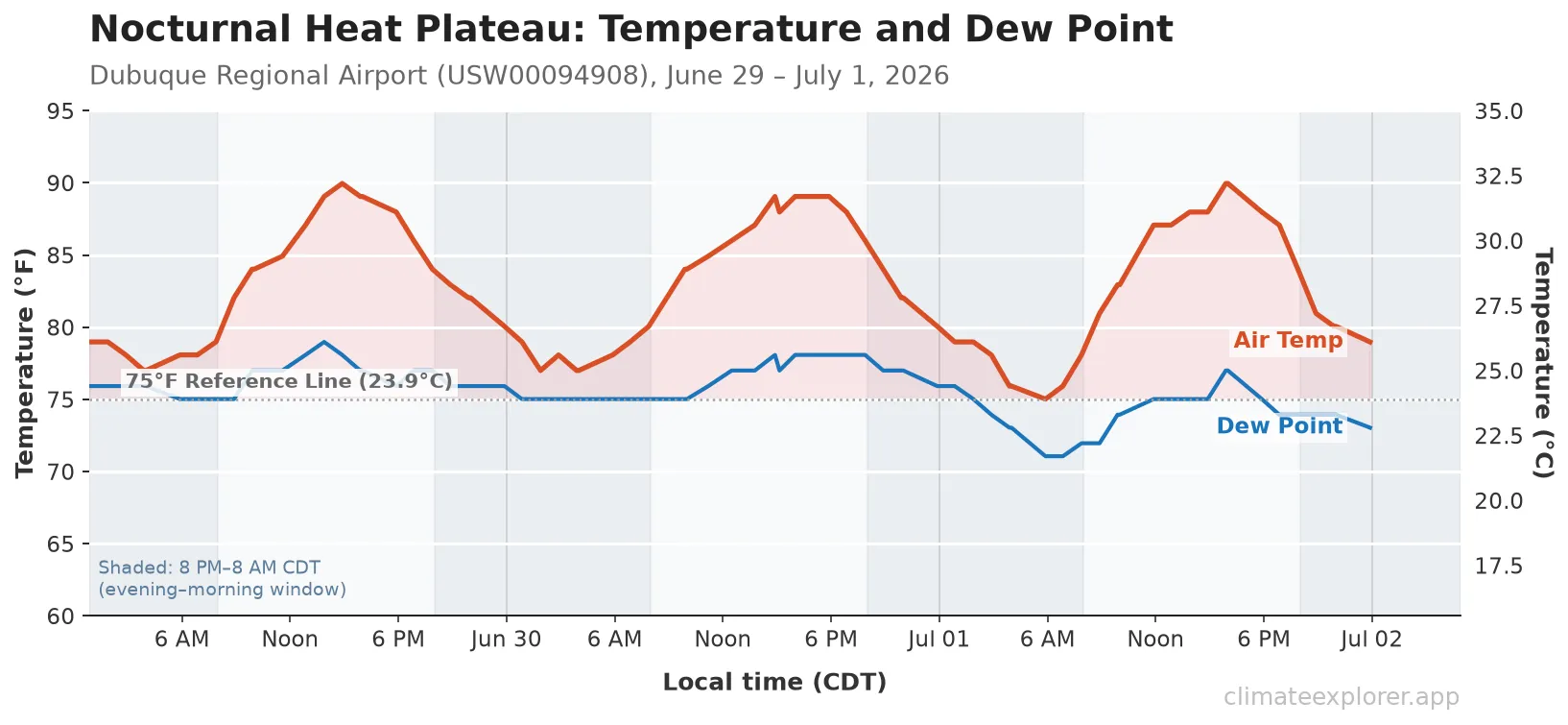
At Dubuque Regional Airport (GHCNh station USW00094908; WIGOS 0-20000-0-72547), 48 of 72 selected hourly observations from 29 June through 1 July 2026 were at or above 80°F (26.7°C). Dew points stayed at or above 70°F (21.1°C) in all 72 observations, coinciding with limited overnight cooling.
Cooling came late
Daily summaries compress each date into a high and low. They do not show when cooling began, how long heat persisted after sunset, or whether the lowest temperature was confined to a short pre-dawn interval.
The selected GHCNh observations show that Dubuque’s daytime maximum was only part of this episode. Warm conditions persisted through the evening and the lowest observations arrived near dawn.
Warm air and high dew points through the night
Dew point describes atmospheric moisture. The selected hourly values were at or above 70°F (21.1°C) for all 72 selected hourly observations during the core event window from June 29 through July 1, 2026. For 57 of those observations (79%), dew points were at or above 75°F (23.9°C).
High atmospheric moisture can reduce nighttime radiative cooling, although clouds, wind and the broader weather pattern also influence overnight temperatures. In this event, unusually high dew points coincided with unusually warm nights. On the afternoon of June 29, the selected hourly air temperature peaked at approximately 90.0°F (32.2°C) at 2:53 PM CDT. At 8:53 PM CDT, the temperature was still approximately 83°F (28.3°C). It did not fall below 80°F (26.7°C) until after midnight; from 12:51 AM through 6:51 AM, selected hourly temperatures remained between 77°F (25.0°C) and 79°F (26.1°C).
On June 30 and July 1, the station again recorded a flat, warm overnight plateau rather than a steep cooling curve.
Historically Rare Nighttime Heat
NWS Quad Cities placed the episode in the context of its official daily climate summaries:
- A warm daily low: NWS reported 77°F (25.0°C) on 30 June as tied with four other dates for Dubuque’s warmest daily low since 1947.
- A three-day run: NWS reported that temperatures did not fall below 75°F (23.9°C) from 29 June through 1 July and identified 18–20 July 2011 as the previous occurrence under its climate-summary convention.
The selected GHCNh rows independently reproduce hourly minima of 77.0°F (25.0°C), 77.0°F (25.0°C) and 75.0°F (23.9°C) for those three local calendar dates. They should not be used to redefine an official daily record: reporting cadence, missing hours, station history and daily-summary conventions can change a historical ranking.
Heat index from the same hourly reports
When heat is combined with high humidity, sweat evaporates less efficiently. The Heat Index is a derived estimate calculated from air temperature and relative humidity; NWS guidance assumes shaded conditions with light winds, and direct sun can make conditions feel hotter.
During the three-day core period, 35 of 72 selected hourly observations (49%) had a calculated Heat Index of at least 90°F (32.2°C), the start of the NWS Extreme Caution range. Twelve observations reached at least 100°F (37.8°C), and the highest calculated value was 104.5°F (40.3°C) on the afternoon of 29 June.
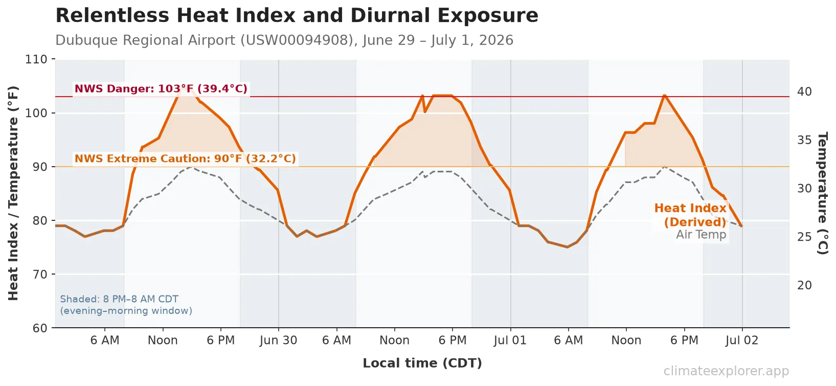
Counts here refer to selected reports, not a continuous measurement of elapsed time above a threshold. The final hourly observations with a calculated heat index of at least 90°F (32.2°C) occurred at approximately 8:53 PM on June 29, 10:00 PM on June 30, and 7:53 PM on July 1. According to the U.S. Centers for Disease Control and Prevention (CDC), lack of nighttime cooling can prevent the body from recovering from the heat of the day.
What Daily Summaries Hide
A daily high and low cannot tell a reader how many observations fell near either end of the range.
The hourly selection adds that detail: 48 of the 72 selected observations from 29 June through 1 July were at least 80°F (26.7°C). The lowest readings were concentrated in a short pre-dawn window. For this station and interval, persistence—not only the daily peak—was the central finding.
Conclusion
While standard climate summaries emphasize daytime maximum temperatures—such as Dubuque’s 90.0°F (32.2°C) peak on 29 June—the defining characteristic of this episode was persistent nighttime heat driven by high atmospheric moisture. Two-thirds of the selected hourly observations remained at or above 80.0°F (26.7°C), with dew points staying at or above 70.0°F (21.1°C) across all 72 hours. Selecting one observation per hour illustrates how elevated dew points coincided with overnight temperature plateaus near 77°F rather than typical pre-dawn cooling curves. The hourly series establishes the duration and sequence of conditions at this airport gauge, but does not redefine official NWS daily summary records or describe microclimates across the wider Upper Mississippi Valley.
Editor’s note: Data current as of July 12, 2026. Retained NOAA GHCNh hourly records and derived heat index calculations were re-verified against source files on September 13, 2026. Upstream station archives remain subject to ongoing routine quality control.
Data Annex
Daily Heat Metrics Summary (Dubuque Regional Airport)
| Date | Lowest selected hourly observation | Highest selected hourly observation | Highest calculated hourly heat index |
|---|---|---|---|
| 2026-06-29 | 77.0°F (25.0°C) | 90.0°F (32.2°C) | 104.5°F (40.3°C) |
| 2026-06-30 | 77.0°F (25.0°C) | 89.1°F (31.7°C) | 103.2°F (39.6°C) |
| 2026-07-01 | 75.0°F (23.9°C) | 90.0°F (32.2°C) | 103.2°F (39.6°C) |
Station Metadata
| Property | Value |
|---|---|
| Station Name | DUBUQUE RGNL AP |
| GHCNh Identifier | USW00094908 |
| WIGOS ID | 0-20000-0-72547 |
| Location | Latitude 42.3983° N, Longitude -90.7092° W, Elevation 317.0 meters (1,040 feet) |
The WIGOS ID is the globally unique station identifier; the GHCNh code is the NOAA archive key.
Data cleaning and time-zone adjustments
The retained GHCNh period-of-record file was parsed again on September 13, 2026. All core counts and the 104.5°F heat-index peak reproduced. Download the 72 selected rows, including the derived relative humidity and heat index. This is a recheck of the retained source snapshot, not a fresh retrieval of every historical observation. Documented bad quality codes were masked for the variables used here. To prevent high-frequency reports from being counted as independent hours, the analysis selected the first report containing valid temperature and dew point in each local clock hour. UTC timestamps were converted to the America/Chicago time zone before local-calendar summaries were calculated.
Derived Heat Index calculations
The Heat Index was calculated using the standard U.S. National Weather Service Rothfusz regression equation (in Fahrenheit) when the average of air temperature and simple heat index was >= 80°F (26.7°C), with adjustments applied for low and high relative humidity. For temperatures below 80°F (26.7°C), the Heat Index was set to the ambient air temperature.
How to explore the data
Open the Dubuque Regional Airport GHCNh view, confirm station USW00094908, inspect the parameter panels in Plots, and use Data → Export Hourly Excel for the selected interval. The GHCNh analysis and export guide explains why the article’s one-report-per-hour calculation differs from simply counting every source row.
Data Sources
- NOAA NCEI GHCNh Archive: NOAA Global Historical Climatology Network Hourly (GHCNh)
- NOAA GHCNh Documentation: Variables, measurement codes and quality codes
- NWS Quad Cities Event Summary: NWS Late-June/Early-July 2026 Heat and Heavy Rain Event Summary
- NWS Heat Index: Heat Index equation and interpretation
- CDC Heat and Health: About heat and health